
From our forthcoming special issue, Geospatial Memory (Media Theory 2/1), Jessica Becking discusses the digital representation of place as problematised by Clement Valla’s artwork.
Records of Representation: Clement Valla’s Postcards from Google Earth
JESSICA BECKING
Trent University, Canada
Abstract
This brief commentary explores images in Clement Valla’s (2010-present) Postcards from Google Earth series from the vantage of aesthetics, landscape theory, and experience of the remote.
Keywords
Documentary art, Google Earth, Landscape, Simulacra, Tourism
Introduction
Clement Valla is a different kind of artist, one that could only exist in a post-modern, digital moment. Unlike artists of the past, for whom “work” was essential to the creative process, today we find equal value in the document. Secondary proof of the work is almost as valuable, if not more valuable, as the work itself. There is a precedent for this kind of approach in the art world of the last fifty years – Hamish Fulton, Ai WeiWei, Richard Long, Andy Goldsworthy, Ana Mendieta, and Robert Smithson to name a few. On some level, all of these artists have utilized the record as a fundamental component of their output. Both observation and the excerpted moment play key roles in their diverse record-based practices. By means of the digital, then, Valla continues the role that the record has come to play in art.
Drawing from W.J.T. Mitchell (2003), we might consider Valla’s work in a different register as engaging with a series of fault lines and ruptures that call attention to Google Earth’s “veiling” of the imperial landscape (30). We could view these images as highlighting the hubris of Google’s attempt to provide a perfect and seamless pictorial representation of the world, implying that Valla’s postcards are the moments of falter, not unlike Google’s tragically failed attempt to map Mount Everest in 2015. To make these claims, however, would be to fail to distinguish between Google Earth’s database of images and Valla’s artistic work. The purpose of this piece is to discuss the latter.
A Simulacrum

Clement Valla’s Postcards from Google Earth (2010-present) raises a number of questions about digitally representing place. Deviating from the static relationships between space and place employed by traditional mapping methods, the Google Earth and Street View mapping initiatives together attempt to create a seamless volumetric representation of the Earth. As Valla suggests, by constantly updating its database with new images gleaned from a variety of sources, “the software edits, re-assembles, processes and packages reality in order to form a very specific and useful model” (2012). It does so mainly by laying satellite imagery of the land over a three-dimensional model of the earth’s topographical features in a process known as texture mapping. While, at first glance, these images appear to record an error, as Valla points out, “these images are not glitches. They are the absolute logical result of the system” (2012).

Indeed, “Google Earth is a database disguised as a photographic representation” (Valla, 2012). The images Valla has chosen to share raise the fact that Google Earth is a database in the first instance, and a means of photographic representation in the second. We might even begin to argue that these aren’t photographic representations of place at all, but rather a simulacrum for one. In the act of stitching together the images and merging them with topographical data we create a hybrid picture map whose relationship to the place it purports to represent is topographically precise; and yet, in its construction as a kind of Frankenstein’s monster of images taken over periods of time, the images are shuffled and selected to create a map that offers the clearest and most wide-ranging image of the place. In this sense, the places as represented through these constructions do not exist in actuality the way the representation suggests it does. Composite pictures of the actual, integrated with precise topographical data, present the impossible. It is more challenging to recognize Google Earth as a simulacrum when the image is devoid of human-made structures. Rocks, trees and water, to a large degree, appear to exist in their natural state; rolling hills and large wooded areas appear to make sense visually, if a little pixelated in their appearance. Where we begin to become aware of the presence of the simulacrum is when the image includes human-made objects – particularly those that span an area where there is a sudden change in elevation or in instances where a multitude of human-made objects are layered on top of each other. The pictorial representation of place, complicated by time gaps and topographical data, struggles to synthesize the land in its natural form and the things which clutter the top of it, and it is in this juxtaposition that the simulacrum becomes evident.
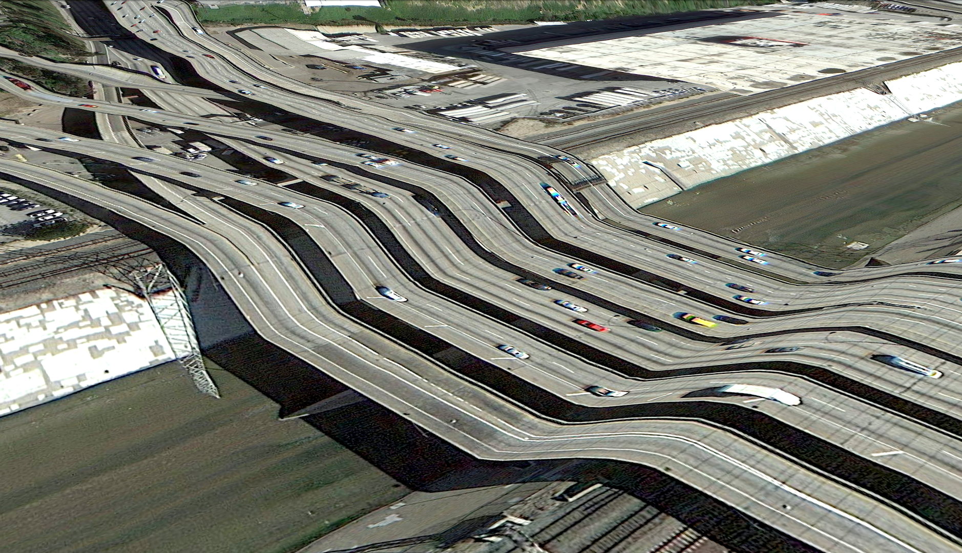
As a result, our world appears, to use Valla’s term, evoking Freud, “uncanny”: that is to say, familiar, more the place than the place itself in some instances, and yet impossible because of either time discrepancies or unresolved complications caused by texture mapping (2012). The uncanny rears its head too, although more subtly, in the lack of cloud covered images which are perpetually lit by a high noon sun (so as to minimize the appearance of shadows). At the time of writing these remarks on Valla’s work, the bridge span in Valla’s Postcard from Google Earth (48°24’31.45″N, 122°38’45.52″W) (Figure 2) has been repaired: virtually corrected to insert a bridge so that the road appears to follow its actual path. Evidence of a car accident – debris, smoke flare, people walking around – marks the satellite record of the road leading into the bridge at Canoe Pass just south of the Canadian border in Washington State. The Google Earth satellite record of Trent University does not include the Student Centre that was built over the last two years. These remarks, like Valla’s images, are date stamps in relation to the world view that Google Earth represents – they, like a photograph of any place, represent the place in the moment of its rendering. The Trent University of Google Earth is circa Summer 2014; there will be the aftermath of a car accident in front of the Canoe Pass bridge in Washington state until the area is photographed again.
By capturing these anomalies and recording them where and when he finds them, Valla is able to create an archive of Google Earth’s development process and record the evolution of this new approach to representing the planet. Valla does not alter the images he discovers, he instead records their existence and tracks their increasing disappearance as Google Earth enhances its capabilities and begins to erase the signatures of its own shortcomings. By sharing these images, Valla is also able to “focus our attention on… the network of algorithms, computers, storage systems, automated cameras, maps, pilots, engineers, photographers, surveyors and map-makers that generate them” (2012). As representations of the earthly surface, these images are less about the images and more about the human and artificial intelligence that went into creating the images. Their classification as a simulacrum of the planet brings our attention both to the distance from which we view worldly events and our simultaneous attempt to have intimate knowledge of them.
A Landscape

We might view Valla’s images as a kind of digital landscape, and thereby put it into conversation with a well-established genre that has been theorized and discussed extensively. Landscape, although readily used in the vernacular as synonymous to the land and its features, is a complex and loaded term. Its various and contentious uses have resulted in an ambiguity that often leads to confusion. Landscape (being both a noun and a verb) can be understood to describe the physical characteristics of the land, the process of refashioning the land, a genre of painting largely associated with the modernist period, and, as W.J.T. Mitchell asserts, a medium in which nature is formalized by culture (2002: 5). Mitchell extends his characterization of landscape as a medium to take on overtones of the negative, such that representations of nature become the “veil” behind which the drive toward imperialism and nationalism reside (Mitchell, 2002: 30).

Regardless of the approach one takes to the discussion of landscape, describing something as “a landscape” ultimately suggests that humans have altered the land in some way. There are many layers of this readily apparent in Valla’s work. Not only are the images the result of a kind of landscaping, caused by the interfacing of photograph and topographical data, such that the photograph, in some senses, becomes landscaped into three dimensional images. More than this, the images exhibit nature mediated by culture, in the sense that they are representative of the changes we have made to the land, and, as was previously mentioned, the product of human labour. Valla’s images also seek to reintroduce the frame to capture singular anomalies out of a representation of the Earth’s surface that sought to do away with the frame altogether. That is, Google Earth’s goal is to create “fluid continuity…a smooth, complete and easily accessible knowledge of the planet’s surface (Valla, 2012). Valla’s records bring the frame back into the picture and consequently ask us to consider whether or not we would classify Valla’s images as landscapes.
Even after laying out the grounds for Valla’s images to be considered landscapes, I still find myself resistant to the idea of classifying them as “landscapes.” This is perhaps because the land is not the subject of these images, nor is it the interaction between the land and things humanity has placed on the land. The subject of these images is the aberrations caused by the “Universal Texture” and, meta-photographically, they comment on the processes employed by Google in its representational mapping of the globe (Valla, 2012).
A Journey


These images suggest a journey, the journey of humankind to depict his world in ever greater exactitude and to put that depiction on display for the world to see, perpetually updated and retooled to achieve the most seamless and complete mapping our world has ever known. These images, however, like Google Earth in general, also remove us from the here and now and invite us to project ourselves into the realms of the virtual. Valla’s language of tourism should not be ignored. These are the images of the armchair traveller: capable of seeing the entire world without ever having to do more than lift a finger. It is an imperfect world, not unlike our own, but the imperfections are not the result of real world events, but of a virtual disconnect between two and three-dimensional representations.
By referring to his images as “postcards”, Valla highlights the fact that they mark out something exceptional. In the same way that a postcard from New York might feature the Statue of Liberty, postcards from Google Earth must feature something that could only be a sight seen on Google Earth. These outliers, moments where actual topography and two-dimensional photographic representation are out of step, are Google Earth’s version of an exceptional view. This exceptional view, however, can only be found when one projects oneself away from the real world and into its timeless simulacrum. A “wish you were here” from a “here” that does not exist and cannot exist.
References
Mitchell, W.J.T. (2002) Landscape and Power, 2nd ed. Chicago: University of Chicago Press.
Valla, C. (2012) ‘The Universal Texture’, Rhizome, http://rhizome.org/editorial/2012/jul/31/universal-texture/ (Accessed: Feb 1. 2018).
Jessica Becking is a Cultural Studies PhD candidate at Trent University in Peterborough, Canada. Her research aims to parallel the current environmental crisis with the demise of the material book and explores how we can treat one as a microcosm for the other. She received her Master of Arts degree in Creative Writing and Publishing from Kingston University in the U.K. in 2012 and is an alumnus of Trinity College, University of Toronto.
Email: jessicabecking@trentu.ca

The ‘version of record’ of this article is available as part of the special issue on Geospatial Memory (Media Theory 2/1) here: http://journalcontent.mediatheoryjournal.org/index.php/mt/article/view/48
The full issue on Geospatial Memory (MT 2/1), edited by Joshua Synenko, is available here: http://journalcontent.mediatheoryjournal.org/index.php/mt/issue/view/2
Leave a Reply