
From our forthcoming special issue, Geospatial Memory (Media Theory 2/1), Manuel Portela, Albert Acedo and Carlos Granell-Canut examine spatial mediation and spatial memories as part of the constitution of places.
Looking for “in-between” Places
MANUEL PORTELA
Universitat Jaume I, Castellón de la Plana, Spain
ALBERT ACEDO
Universidade NOVA de Lisboa, Portugal
CARLOS GRANELL-CANUT
Universitat Jaume I, Castellón de la Plana, Spain
Abstract
This article develops the concept of “in-between” places in relation to the study of language, perceptions and memories within the broader mediation of cartography. We held an empirical qualitative study in the city of Lisbon, Portugal, where a group of participants (1) performed a web map-survey to identify the spatial dimensions of their sense of place, (2) had a joint discussion about the representations and memories associated with their chosen places, and, finally, (3) took a go-along walk to obtain a deeper definition and characterization of them. Results suggest that analog and digital maps generate different virtual images of space, while the navigational use of digital maps in particular generates multiple representations of the territory. The mediation of different narrations and the description of encounters within the Person-Place-Process triad helped us to establish the importance of in-between places for a complete conceptualization of place.
Keywords
Place, sense of place, cartography, mediation, in-between places, spatial memories
Introduction
Places are too often represented by cartographic technologies with excessive attention put on the Person-Place relation. We have therefore focused our work on studying how maps can further benefit from inquiry into the Process of place attachment. Though Process has been scarcely studied (Lewicka, 2011), it has been taken up by Scannell and Gifford (2010), who proposed a model in which place attachment is organized in a Person–Process–Place (PPP) framework. Process refers to three main aspects of experience: Affect, Cognition and Behaviour. In the following, we use this framework to study daily life activities, noting that such activities unveil much of the meaning of places. Granted, it is known that daily activities are resistant to being represented by rational models, and indeed that 95% of our daily life behaviour is not allocated in our consciousness (Thrift et al., 2008). In this vein, we take a non-representational approach because it focuses on the procedural and performative aspects of life, with the potential to develop a speculative topography from embodied emergent experiences (McCormack, 2003).
As a conceptual departure for identifying spaces that emerge in embodied experience, we supplement our analysis with recent work from Downey et al. (2016), who emphasise the liminality of spaces, identified also as “in-between.” Borrowing from Eric Prieto’s version of the concept, they write that “in-between” spaces tend to run the risk of falling between categories, of being misunderstood, and of having their importance ignored. This is because:
[Their] spatial (physical and/or conceptual) position implies both integration of and resistance to whatever is either side of or outside of the in-between. […] One cannot occupy an in-between space or exist (in-)between two binary states without a resultant tension and/or mobility between both elements of the binary, which resist but also merge with the middle in-between (Downey et al., 2016:3).
Consequently, “in-between” spaces are at times difficult to define and describe, because the procedural attributes that those spaces present were key to our analysis.
We carried out an experiment based on three different methods oriented to capture in-between spaces with a special focus on the PPP triad. The diversity of methods allowed us to link lived experiences and enacted memories in order to understand multiple and overlapping experiences of places. Furthermore, collaborative discussions and walking activities helped to redefine both individual and shared experiences of place. By doing so, the notion of the “in-between” helped us to understand the complexity of place as constituted, shared and represented, resulting in the acknowledgement of a sense of place as simultaneously enacted, performed and re-imagined.
This article is structured in four parts. First, we briefly review previous work related to the definition of place and the mediation of maps. Second, we describe the experiment, and the suitability of the proposed methods to capture and analyse sense of place. Third, we describe our findings to provide an understanding of “in-between” places. Fourth, we discuss the role of new media and technologies for cultivating, enhancing and engaging new places.
Understanding the definition of place
Place and space are intrinsic and complex components of any city, and have been studied from diverse disciplines such as Human Geography (November et al., 2010), Environmental Psychology (Manzo, 2005; Gifford, 2014), and Sociology (Law, 2008). Urban spaces can be configured by different social groups or individuals according to their lifestyle, common places, intentions and choreographies, leading to a continuous multiplicity of publics (Sheller, 2004; Jenkins et al., 2016). Place can be defined as “a particular space which is covered with meanings and values by the users” (Najafi et al., 2011: 187) and plays a significant role in human behaviour and mental health (McAndrew, 1993).
Norberg-Schulz refers to the Genius Loci as “the concrete reality man has to face and come to terms with in his daily life” (Norberg-Schulz, 1980:5). Placelessness, or the lack of sense of place, can lead to frustration and lack of character or monotony (Lynch, 1960; Relph, 2016; Casey, 2001). “Non-place” was famously described by Marc Augé (1995) as a space that “cannot be defined as relational, or historical, or concerned with identity” (77). Additionally, Edward Relph argued that a paradoxical relation exists in which places cannot be permanently designated along the spectrum between “place” and “non-place,” but are rather enacted and relational with respect to these terms (Relph, 2016).
Our attachment to place is another important factor, as something that is often framed in emotional terms (Najafi et al., 2011). According to Gifford (2014), for example, place attachment can provide us with a sense of security, belongingness, continuity, and it also fosters restoration and facilitates the successful pursuit of one’s goals.
A sense of place is psychological but also interactional and physical. It “influences attitudes and behaviour beyond itself” (Gifford, 2014: 562). As Najafi et al. (2011) point out, “sense of place as an emotional bonding between people and places is created after cognition” (189), which implies that there are social, cultural and personal motivations that exist both before and after our direct affection with it.
Places and the in-between
Lewicka (2011) found that there are only a few studies that correlate place attachment to the scale of a place, arguing that neighbourhood scale in particular is rarely related to place attachment. However, the notion of place has undoubtedly undergone many changes together with the transformation of cities.
Duff’s (2010) distinction of “place” as “thick” or “thin” only further enriches our argument. While these concepts appear to resemble the distinction between places and non-places, the former pair is unique in that it takes affect as a point of departure. This means that the construction of place does not reside in the place itself but in the relational force between places and bodies. For Duff, thick places can be cultivated by local appropriations. Thickness relates the importance of intimacy to practices and encounters that occur in a place to determine the construction of meaning and belonging to that place, and thus leads to diverse affective atmospheres. Affective atmospheres capture the “emotional feel of place, as well as the store of action-potential, the dispositions and agencies, potentially enactable in that place” (Duff, 2010: 881). To put it another way, the concept of affective atmospheres helps to enact the cultivation of thick places, and to induce sensations in our body. Taking Norberg-Schulz’s approach into consideration, affect emerges in the act of dwelling; it is what gathers people.
Mediations of the map
Maps are never static, objective or simply utilitarian. They rather dictate how we see the world, and, as such, they are epistemological and ontological devices (Dodge et al., 2009). A performative perspective on representations of the world would suggest that both the epistemological and ontological dimensions of the map are enacted simultaneously (Law, 2008: 13). Agnieszka Leszczynski (2015), for instance, suggests that space “is instead ontogenetic –- a material and social reality that is constantly brought into being through embodied socio-technical practices, such as enrolments and deployments of spatial media in the practices and spaces of the every-day” (Leszczynski, 2015:6).
Bruno Latour (2011) observed that maps are not only mobile but also immutable, presentable, readable and combinable with one another. He writes that “mappings are rarely unfolded in isolation, but are embedded within wider discursive fields and forms of praxis” (Kitchin et. al., 2013:15). Consequently, as Gerlach (2014) points out, distinctions between ontology and epistemology disappear in the performativity of maps, because it is not that representations coincide with the territory, so much as it is the territory that fits onto the map (Paraskevopoulou et al., 2008).
However, maps are also spatial stories (De Certeau, 1984) and the very process of generating, translating and distributing these stories, destroys the past context, including its relation to other parts of the story, in which the foundation was made and only the narrative remains. Stories thus “carry out a labour that constantly transforms places into spaces, or spaces into places” (De Certeau, 2002:75). The act in which the narrative is taking part transforms the map in a tool for legitimated coercion and coercive actions.
The meanings of inscriptions are also created during the act of using them. Kenneth Liberman (2014b) argues that the interpretation of maps refers less to the act of reading them as it does to the way maps organize both knowledge and the senses, and therefore in how maps are made evident to those who are reading them. Recent works show similar results in the interaction mediated by digital and mobile maps (Laurier et al., 2016; Bouvin et al., 2006), with the understanding that walking is never “merely walking.”
Leszczynski (2015) considers spatial media, including digital maps, “as a basis from which to grapple with the socio-spatial effects and significance of these technological phenomena through opening up the possibilities for engaging them in terms of ontological conditions of mediation” (3). She therefore introduces the always-mediated reality and the necessity to discuss the articulation between the virtual and the physical in relative terms, and avoids treating them as divergent spaces. But in terms of emotions, feelings and affects, working with such liminality also entails working with that emergence (McCormack, 2003). Thus, the virtual is in the realm of potentiality. It is in this aspect that Gerlach (2014) introduces the idea of vernacular maps, in which legending is to consider affect, the virtual and the performative, and to introduce “reimaginations, affect, events and becomings” into the process (3).
In this paper, we demonstrate a multi-layered approach to understand the emergence of in-between places, and argue that the relation between ontological, utilitarian and navigational definitions of place are mutually tied together in the use of maps.
Description of the experiment
The capital of Portugal, Lisbon, is currently occupied by a swarm of tourists, students and inhabitants, and draws a fascinating place to conduct our experiment. In 2012, Lisbon suffered an important administrative restructuring, moving from 53 to 24 parishes. This adjustment led to a considerable transformation of Lisbon’s autonomous governments (freguesias) by changing their names, boundaries and political administrations. During the last two years, the city is also subject to a gentrification that is having a huge impact on its culture, economy and landscape. This conversion became another starting point for thinking about the sense of place of Lisbon’s inhabitants.
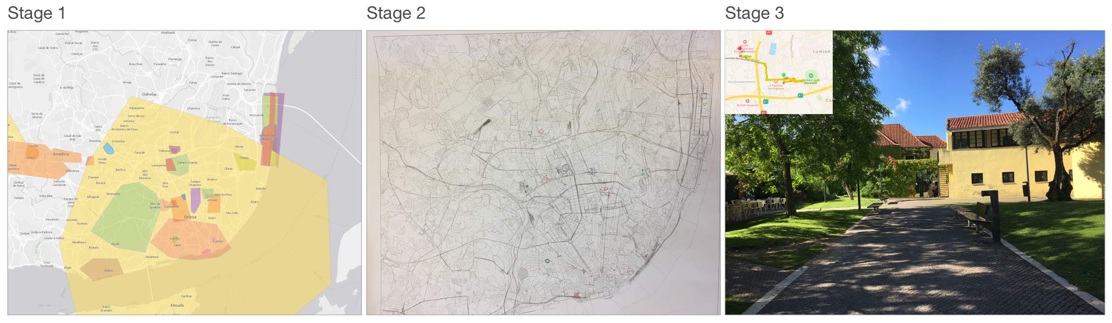
We carried out an experiment to grasp the emergence of the in-between by using different methods. We recruited 10 students from our University and divided them into two groups regarding their availability for the meetings. The first group was composed of three females and one male, while the second group was composed of three females and three males. All of them were between 20 and 33 years old. The experiment was designed in three stages (Figure 1), with each being conducted with different settings, as described below. Both groups accomplished the entire experiment successfully.

Online map-survey (stage 1)
Participants were asked to fill in an online map-survey (Acedo et al., 2017a). The ad-hoc survey was meant to understand and spatialize participants’ sense of place and social capital in the geographical region of Lisbon. Participants were asked to draw areas of interest regarding (A) the places they belong (i.e. where they fit in), and the relations that they have towards the geographical area, (B) the groups that they belong to, and the places where those relations between human collectives and interactions arise as fruits of trust, reciprocity and cooperation, and (C) the places where they are willing to participate in civic activities.
Everyday mapping activities of citizens through platforms such as Google Maps and OpenStreetMaps answer the need to define a route or mark a location that is related with a geometrical perception of space rather than an individual perception of a singular place (Roche, 2016). Sui and Goodchild (2011) already noted that Geographic Information Systems (GIS) can be considered as media, since they allow to interact between virtual and physical territories. Nevertheless, it should be noted that “spatial media intrinsically do not conform to systems metaphors that underwrote myriad definitions of GIS” (Leszczynski, 2015: 3). The goal of this web map-based survey was to situate citizens’ significant places and to mark precisely where their meaningful relationships take place. By drawing these areas of interest and giving them a name, the participants valued those places independently and, simultaneously, they reached a better understanding of urban spaces.
Workshop (stage 2)
After completing the online map-survey, we invited both groups to join and work with their feelings and emotions as triggers. The activity was set in a room with a shared map on top of a table, and a camera hanging from the ceiling to record the interactions and the use of the provided tools. Two of the authors took the role of facilitating the process in Stages 2 and 3, taking notes, providing guidance and taking part of the discussion. The duration was one hour, structured in five parts or phases:
(Part A) We gave participants a sheet where they could list important, meaningful or significant places (see Duff, 2010) along with their feelings and emotions regarding each place. The proposed questions were: Which places do you recognize that are yours in the daily life? Which activities do you carry and take place there? What are the feelings that you have got when you think of such places? What is the intensity of those feelings?
(Part B) After completing the list, they were asked to value them in the Affective Appraisal of Environment marker (Russell and Lanius, 1984). The affective appraisal theory assumes that people can judge the ability of a place to alter feelings, in that sense, the marker is a two-dimensional graph (pleasantness and arousal) that allows to categorize places. In our case, we wanted to use it, not to effectively judge the places, but as an exercise to promote deeper thinking about individual feelings related to a place, before explaining it to the group.
(Part C) Next, each participant was asked to mention (one at a time) the places that he/she had in the list, locate it on the map, and explain to other participants why he/she selected that place, what intensities and emotions brought to him/her, and how these distinguished from other emotions. After doing so, participants were required to rank the place before continuing with the next on the list. This constituted the main part of the workshop activity since meaningful discussions appeared on it.
(Part D) After the main part, participants were required to think whether they wanted to share another place that was not on their list, and might be related to familial relations, social relations, or would even represent to some extent the city.
(Part E) Finally, we asked participants if they wanted to change the ranking they have chosen for the places, if they wanted to change the appraisal of the place, and if they felt that they would change the geographical areas that they have marked in the Map-Survey (stage 1).
Go-along walk (stage 3)
A go-along walk is an in-depth qualitative interview method that is useful “for exploring – and subsequently improving understanding of – people’s experiences of their local residential context” (Carpiano, 2009: 3). It facilitates the analysis of everyday practices in place, the relations with other agents, and to keep sensitive to the affective dimension of place-making activities (Duff, 2010).
After selecting an arbitrary point of departure, some participants of each group performed a walking exercise. From each group, we selected three participants to be part of the activity, while two of them where the guides of the walking tour and the other one was who held an action camera with a head-mount. We asked participants to meet in a metro station as a point of departure, and the guides took the group to the places mentioned in the previous workshop session (stage 2). The main intention was to differentiate the places that they have pointed to in the map and how they relate them to vivid spaces, what comes up and how others relate their own experiences. Because we did not want to evaluate their map-reading skills, we did avoid the use of maps during the walking and let the guides choose the path to follow.
The walking activity was oriented to understand the affective dimension, but also to understand how places pointed out in the previous stages are enacted, omitted, mentioned and re-created in practice. For that reason, our guidance and interventions were focused on remarking and inquiring the group about such places. As outputs, we got GPS tracking points and paths, field notes and video recordings, which were analysed after, in comparison with the other materials.
The multi-layer approach
The experiment, which was made up of three different stages, led to a complex map of how places are built, and the virtualities and imaginaries that work between the qualitative, quantitative and performative methods.

Figure 2 shows three scopes (columns) of analysis for each of the stages; layers of analysis are seen per each row. For example, the first scope contains the emotions, feelings and affects layers. The combination of layers within scopes allowed us to observe the phenomenon differently. For clarity in the explanation, the division between scopes and layers is not so rigid as it may appear, because, in practice, we might have used all layers for any of the stages. Nevertheless, we found that specific combinations of scopes-layers eased the development of certain stages and clarified the search for in-between places. In that sense, we used a holistic approach to detect the best combination given the following empirical analysis. Working as filters, each combination of scope-layer led us to reconstruct our findings to identify and determine in-between places. It was a relational exercise of using different means and strategies to develop our experimental activities, involving different layers of knowledge, states and skills. We suggest that in-between places can be unveiled working in the interweaving of what is represented and what is not.
For the analysis, we transcribed the conversations from Stages 2 and 3 by using Jefferson’s transcription system (Jefferson, 2004). As Gene Lerner explained:
Understanding turn-taking for conversation and other forms of talk-in-interaction is key to understanding human conduct, because most actions carried out through talking are shaped by the organization of that talk into speaking turns: it shapes how speakers compose their contributions, it shapes where they position those contributions in the ongoing interaction, and it shapes when they get to participate (Lerner, 2004: 4).
We then analysed the video recordings by means of the noticing method (Laurier, 2014). This allowed us to pay attention to gestures and negotiation of meaning, by repeating the recordings many times.
We used cartography as a complementary tool and as an excuse to participants to talk about their places. To analyse them, we overlapped the data resulting from the Stages onto an ArcGIS map to explore them together to find correlations between what was said in the meetings with what was effectively marked. Besides, to make sense of the entire process, we reviewed the resulting material several times, reading it through different scopes and layers, searching for clues of in-between places.
Findings
During the experiment, we noticed that the knowledge of the territory and its relation to the cartography was different between participants. One of them was very keen on finding places, and helped others on this activity. He expressed his interest in the city and easily related the space to the map. But strolling around the city alone does not suffice to fully develop such skills. Other participants who stated they liked walking around had more difficulties to determine where the places were, and used the relational method explained above. As such, we argue that there are different types of spatial memories, which are also enacted by different types of mediations.
In the following we use the three proposed scopes to analyse the results of the experiment to better understand how each method unveils different aspects of participants’ spatial memories.
Ontological, mimetic and navigational results
The mimetic representation of the territory is not directly mapped to how it is reproduced in our virtual images of space (November et al., 2010), losing the correlation between what we experience and what we can say about places. This was obvious in the experiment when people tried to mark, describe and orient others in the workshop. Moreover, more than once in the exercise, the provided maps generated confusion regarding the place they wanted to show. This situation forced participants to abandon the map as a representation and describe the place by its physical characteristics, activities and personal feelings.
Places are personal appropriations of spaces, and by sharing them to others, participants had to try to imagine what were the perceived characteristics of the place being shared. Having said that, when a participant shared a place, the starting point was always easily recognised by others, such a metro station, a shopping centre or a stadium. While the other participants recovered the virtual image of the place, the participant who was describing the place changed the description to focus on the place that he/she wanted to share. This misunderstanding or ambiguity is manifested in the following description where a participant mentions a station (Santa Apolonia) trying to orient others, but without success:
“Ohh! Actually, I don’t know much about this place but I’ve been visited through outside the station. There is some traditional market as well the street market. And I found it very interesting. I used to do photography over there. And Santa Apolonia is also one of my favourite places to visit, because there is differentiation. I’m the kind of person who always loves to travel, so I can be anywhere.”
The group, then, tried to recalibrate their thoughts to understand what the participant said, but not without producing moments of confusion during which some participants got lost:
“That market was a kind of street market in the traditional way. I mean street harbour like this, they have the cars and there are in the gardens on the road side. They are having new products, second hand, maybe, or some traditional. And then sometimes you find some very good articles over there”
There were moments of reflexivity when someone could name or generate a consensus about what people were talking about. In the following, “A” (one of the authors), tried to share with the group that he realized which place the participant was talking about. However, the others took some time to catch it. We can notice that on the following transcription made in Jefferson’s system:

Additionally, we observed in the transcriptions that not only the perception and values of place were represented, but also the participant’s personality. Therefore, the ontological feature of maps is taken by each participant as he/she uses it to express his/her identity and vision, while others can access to that vision to understand the participant’s vision.
Assistive or complement lectures
Such recalibrations and stabilizations are common in group discussions. However, maps mediate in the process in different ways. In one of the groups, after looking for specific places in the analog map, because it lacked street labels and other references, participants were lost. We decided to use a complementary digital map based on the OpenStreetMaps service, which was projected on the wall of the room. Then, participants tried to match the digital reference to the analog one. While it took time to find the right places, it was necessary an intermediary reference to localize the area in which the place was related to, and then, look for the specific place.
Digital artefacts, media and information devices surrounding our daily life activities are interconnected both in terms of their functions and meanings creating physical and digital ecologies (Fuller, 2005; Jung et al., 2008). Platforms like Google Maps and OSM enable us to reimagine our location and to develop a relational perspective. They are publicly accessible mapping platforms that open new ways to locate information and wayfinding practices. For that reason, we forced participants to think outside their own practices of understanding the territory, making them amplify the scope of digital maps to solve their situation and to learn from it.
For historical or touristic purposes, only relevant places are marked to quickly find them, but usually these maps lack other common references or places, like fast food chains, banks, or buildings that foreigners can easily recognize. Once a tourist gets lost, he/she then tries to match the references on the map with the place where she is, and the absence of common references may make the navigational task difficult (Ishikawa and Takahashi, 2013). In our case, the multiple references to metro stations, fast food chains and other commonly known places, helped to mediate the locations. By doing so, participants unveiled also activities that they used to practice in these places but were not included in the list of places of preference.
The mediation of such places unveils in-between places, revealing a set of practices that are not conscious and, possibly hidden from the rationale of the group. This is where the intersection between the representational and non-representational is found useful.
Place, people and process
During the walking activity of the first group, one of the participants led the group to her special place. We found that she had difficulty to put a name and to give a concrete description of the place. For that reason, the participant complemented it by gestures and specific descriptions, references and negotiations until the group realized what she was trying to communicate.

Because it was a common space for two of the participants, we decided to do the go-along walk around Telherias station, the starting point of two of the mentioned places. When the participant started to guide us to the place, she explained that she found the place (Point C, in Figure 3) by chance, while she was heading to a meeting with her supervisor in the supermarket “Continente” (Point B). We reproduced that path to understand where and under which circumstances affects raised on that activity. The place that she found so special appeared in contrast between two crowded places, as an oasis, with the characteristics that she preferred (peaceful, relaxing).
We found that during the workshop, she only could mention the metro station (Telherias) near the place, but since she could not describe it in more detail, she gave up on explaining more about that place. Neither could she point it on the map, she only realized where the place was when other participants named the station.
“And going out of metro, it was a new place for me […] During my whole walk, I found it very pleasant. Very peaceful. Something positive. I mean, you are walking towards the Continent from your metro station that there is a long walk. And I found it very peaceful and I was doing, I have a brainstorming during there so I have very positive thoughts. I found that. I mean, I’ve been going there after that two or three times, just for. Because of my thesis.”
Edensor (2012) argued that affects are always anticipated, having a social, cultural and personal background. In this case, the participant’s intention to find a place that brought affect was clear. She prefers pleasant, quiet places, with natural elements, in which one can enjoy certain activities such as reading or studying. But the fact of sharing it with others turned to be a difficult task to accomplish. In the walking, she resorted some words such as magical place or by referring to fictional scenarios. The group accommodated their understanding of the meaning of what she was saying:
“I know that the place is very common, but the ambience, the entrance is… and, I sit on that desk and… that entrance, that entrance. The green one. The entrance of… Like a fairy tale, Alice in the wonderland, or Scotland.”
The participant also expressed the importance of repetition as an act of affirmation of her feelings: “It really makes me happy. I have been there. Eh, I’ve been coming here for more than three times. So, whenever I came here I use to sit here. At least for thirty or forty minutes.” She then reaffirms the feeling when explaining how it works, and in which situation she found it: “But it appears that, if I would sit here, the magic will remain there.”
Regarding this last case, we understand that the activity of mapping is not just a construction of symbolic reference, but that it is activated in time. As Liberman put in words, “a map does not provide for those practices prior to an occasion—instead, it is the occasion that affords the map its coherency, a coherency not of ideas but of a collection of practices” (Liberman, 2014a: 47). But at the same time, the different activities allowed us to complete the virtual aspect of the place, only by the mediation of several cartographies, verbal descriptions, physical gestures, negotiation between participants and our own ideas, feelings and emotions. What grouped all those mediations together was the contagion of affects (Thrift et al., 2008), which made us react in such a way that we felt the importance of such place. It was that specific moment of being in the place, after a sequence of synchronous and asynchronous activities and choreographies that permitted us to arrive a moment of reflexivity and understanding. We can argue that in-between places are special, hard to communicate and represent, but often necessitating and/or leading to unique moments of common understanding within a group.
The process of reconstructing spatial memories
Activity groups are embedded in a negotiation of meaning and personal exposure. In a Wittgensteinian view, given the lack of necessary landmarks and contextual clues in conversations, Liberman (2012) affirms that “the meaning of a word is naturally unstable over the course of a conversation” (263), and, for that reason, “meanings do not reside in people’s heads but in the world” (266). Participants in both groups re-arranged their places to follow the conversation and the general meaning of the experiment. The importance of places, then, are entangled to the utterances of other participants.
During the workshop, the first group spotted publicly known places that may be of interest to tourists, including sites of natural or cultural heritage. Because of that, organizers had to force the conversation to go to personal places. However, in the second group, because most of them knew each other before, they mentioned places that are common to most of them. In both cases, personal places came in the second or third attempt of describing places. Lewicka (2011), by comparing other studies, found that participants tend to prefer places by environmental features and characteristics of place than by social ones (family/friends). In their personal lists of places, we can corroborate Lewicka’s findings, given that at least half of the participants put the University and Arco do Cego (the main square where they used to meet) in the top of their lists. Nevertheless, comparing to the maps from stage 1, with the exception for one participant, none of those places where marked as important regarding social capital or place attachment. Here, places like Belem (the most popular touristic place of the city) just came up in the group activity. Consequently, in-between places are also mediated by popular images, common assumptions and knowledge.
Feelings, emotions and affects
Looking at the words used by participants to describe their emotions in relation to places, we found that many of them did not describe emotions but activities or relationships with these places. For example, in the second group, one participant pointed to a square where he socializes with his friends and university colleagues; when we asked him for emotions, he only answered “hangout.” What we understood is that multiple emotions came up at the same time, making the explanation confusing. Therefore, there is not a single rational aspect, emotion or feeling pertinent to a place, but multiple and mixed as participants remember them. Considering that emotions are “constituted categories in relation to which the felt intensity of experience is articulated” (McCormack, 2003: 495), we realized that some are not yet stablished, but are becoming in the course of the discussion.
In some cases, for representing what they feel about, participants decided to describe the place first, then what they used to do there, and why they liked it. Because of the difficulty to assign a word to emotions and feelings, a place is represented as a set of descriptions and gestures that altogether try to transmit the felt attunement (Edensor, 2012). Besides, we perceived the unsuitability of some tools, such as digital and analog maps to describe some emotions. In the analysis of what they have drawn, we observed that, in a first instance, participants avoided these places in favour of more common places, and only after a prudent time, they were able to communicate more personal places that were not on the list.
On the other hand, the places that were top-ranked sometimes fit with specific feelings or emotions. For example, one participant mentioned reiteratively pleasant and quiet places, as something that she was expected for her selected places, and in fact she thought it was a common expectation.

For the use of the Appraisal Marker most participants chose merely pleasant places, and very few thought of unpleasant places. More interestingly, we asked later if they wanted to move one marker to another position. Despite the fact that few participants made changes, one case was paradigmatic. The chosen place was the childhood house of one of the participants. Since the neighbourhood (Chelas) has a bad reputation, the discussion shifted from his description of individual concern to a more public debate regarding insecurity and other social consequences. Though it was the participant who mentioned the bad reputation of the neighbourhood, he probably did so with the intention to differentiate its public reputation of that space from his own experience and appreciation: “The area where my grandparents live was not problematic. It’s a fine place,” he confessed. Then, another participant (who knew him) commented on her feeling of safety: “Sometimes it can be a scary place but nothing bad happened to me there,” she said. As a second witness, she helped to build a stronger argument, saving his negotiation between a personal and a public definition of the place. Consequently, the first participant decided to move the marker to a more pleasant position (Figure 4), most probably because of the negotiation that took place.
On the scale of places
Participants of both groups recognized Parque das Nações as a public space, but it was referenced to different activities. The place is a parish that was built for a World Fair in 1998 with a series of venues, such as a shopping mall, a riverside, restaurants and a concert hall. It is well-known for leisure activities, tourism and shopping. There is also a set of residential buildings that were built after the fair, and one of the participants lived there since her childhood.
For her, the place has a different value than that of the rest of participants. Although the descriptions made during the walking were levelled down to a more historical narration, when we analysed the data we found that she has selected all the areas of the parish, while others only selected a specific sector of it. We can assume that she has more attachment to the entire parish area and knows many places that she can be related to, while others only referenced few places and, consequently, felt less attached to that place.
Exercises through distinct means and tools required participants to point to places differently. In the first stage, we asked them to define areas of influence, regarding sense of place or attachment, while the tool also forced them to do so in a specific manner. In the second stage, we gave them symbols to represent places, which allowed participants to point to a specific place, and not an entire area. For example, inside Parque das Nações, people placed marks at different venues, while they selected the entire area when using the digital tool. In some cases, participants, by freehand drawing, also used the symbols to fit an entire area. Therefore, they adapted the given tools to fit their intentions, and defined the scale to which they wanted to show their space appropriation. Without the practical opportunity to work remotely, the appropriateness of analog tools fits much better into the level and scale of representation of places.
Conclusion
In this paper, we put in perspective the development of representational systems for communicating what people consider a place. With the adoption of digital platforms, the meaning of what a private or public space changed, as well as individual and group relationships with space (de Waal, 2014). Our relationship with the urban space is also changing due to the use of software enabled devices (Kitchin and Dodge, 2011).
The notion of place, that has been discussed for decades is in constant transformation. As Duff pointed out, we should not try to force it and understand that levelled down places are also opportunities to generate new personal, appropriated spaces. For that reason, we consider that, using new available technologies we can look at new ways of narrating and communicating those places. Thrift et al. (2008) said that new possibilities of visualizing maps by interactive means are an opportunity to also capture such changes on affect. And our call here was to critically face the use of media to represent what is harder to represent, rather than continuously to reproduce the same ambiguity between common spaces and places.
None of these developments are thought to raise, share and contribute any personal value of space. As we saw in our exercises, in-between places are commonly unknown spaces, which are only shared between participants when enough confidence among them exists. Beyond any place that has been pointed during the activity, it remains to be understood why some places that participants have put on the list were not mentioned during the group discussion. Omitted and absent places are also significant. As Gerlach (2014) writes in connection with Gilles Deleuze’s manifold cartographies, it is in the multiple ‘and, and, and…’ (Gerlach, 2014) of descriptions, embodiments and processes that we can find these in-between places.
Much more understanding is needed on how in-between places can be part of everyday life, and what the difficulty of capture and discuss its meaning implies for future technological developments. In this paper, we have examined spatial mediation and spatial memories as part of the constitution of places, as a collective knowledge, and that this may help to delineate new methods to create, share and capture them with or without digital artefacts.
Given the proposed framework in Figure 2, we account that some methods were more suitable regarding specific layers. For example, the go-along walk provoked circulation of affect and, at the same time, the focus on the Process for the constitution of meaning. The workshop helped us to discuss emotions, while the circulation of affect was also spotted in the discussion. However, the use of the map as navigational device offered a focus on Places and Process. We encourage ourselves to continue researching on relating scopes and layers in further experiments. However, a situated reflexivity on the discussions and mediations is hard to reproduce. Therefore, we expect that more studies will focus on the Process of creating places and the mediation of cartography.
References
Acedo, A., Mendoza Silva, G. M., Painho, M., & Casteleyn, S. (2017) ‘One tool to spatialize all: sense of place, social capital and civic engagement’. In A. Bregt, T.
Sarjakoski, R. van Lammeren, & F. Rip (Eds.), Societal Geo-Innovation: short papers, posters and poster abstracts of the 20th AGILE Conference on Geographic Information Science. Wageningen, May 9-12, 2017 (p. 5). Wageningen, Netherlands. Retrieved from https://agile-online.org/index.php/conference/proceedings/proceedings-2017
Acedo, A., Painho, M., & Casteleyn, S. (2017) ‘Place and city: Operationalizing sense of place and social capital in the urban context’. Transactions in GIS, 21(3), 503–520. http://doi.org/10.1111/tgis.12282
Andrews, G. J., Chen, S., & Myers, S. (2014) ‘Social Science & Medicine The “taking place” of health and wellbeing: Towards non-representational theory’. Social Science & Medicine, 108, 210–222. http://doi.org/10.1016/j.socscimed.2014.02.037
Auge, M. (1995) Non-places, Introduction to an anthropology of supermodernity. Verso Books.
Bouvin, N. O., Brodersen, C., Bødker, S., Hansen, A., & Klokmose, C. N. (2006) ‘A Comparative Study of Map Use’. In CHI ’06 Extended Abstracts on Human Factors in Computing Systems (pp. 592–597). New York, NY, USA: ACM. http://doi.org/10.1145/1125451.1125575
Carpiano, R. M. (2009) ‘Come take a walk with me: The “Go-Along” interview as a novel method for studying the implications of place for health and well-being’. Health and Place, 15(1), 263–272. http://doi.org/10.1016/j.healthplace.2008.05.003
Casey, E. S. (2001). ‘Between Geography and Philosophy: What Does It Mean to Be in the Place-World?’ Annals of the Association of American Geographers, 91(4), 683–693. http://doi.org/10.1111/0004-5608.00266
De Certeau, M. (1984) The practices of everyday life. University of California Press.
De Certeau, M. (2002) ‘Spatial stories’. What Is Architecture, 72–87.
de Waal, M. (2014) The City as Interface: How New Media Are Changing the City Reflect. nai010. Retrieved from http://www.amazon.es/City-Interface-Changing-Reflect-Paperback/dp/B00ZM2TK70/ref=sr_1_1?s=books&ie=UTF8&qid=1448722097&sr=1-1
Dodge, M., Kitchin, R., & Perkins, C. (Eds.). (2009) Rethinking Maps. Oxon: Routledge. Retrieved from http://www.amazon.com/dp/0415461529
Downey, D., Kinane, I., & Parker, E. (Eds.). (2016) Landscapes of Liminality: Between Space and Place. Rowman & Littlefield Publishers, Inc.
Duff, C. (2010) ‘On the role of affect and practice in the production of place’. Environment and Planning D: Society and Space, 28(5), 881–895. http://doi.org/10.1068/d16209
Edensor, T. (2012) ‘Illuminated atmospheres: Anticipating and reproducing the flow of affective experience in Blackpool’. Environment and Planning D: Society and Space, 30(6), 1103–1122. http://doi.org/10.1068/d12211
Escolar, M. (2003) ‘Exploration, Cartography and the Modernization of State Power’. In State/Space (pp. 27–52). Malden, MA, USA: Blackwell Publishing. http://doi.org/10.1002/9780470755686.ch2
Fuller, M. (2005) Media Ecologies: Materialist energies in Art and Technoculture. Technology. Cambridge, Mass.: The MIT Press. Retrieved from https://books.google.pt/books?id=1FLIHNPucroC
Gerlach, J. (2014) ‘Lines, contours and legends’. Progress in Human Geography, 38(1), 22–39. http://doi.org/10.1177/0309132513490594
Gifford, R. (2014) ‘Environmental psychology matters’. Annual Review of Psychology, 65(September), 541–79. http://doi.org/10.1146/annurev-psych-010213-115048
Ishikawa, T., & Takahashi, K. (2013). ‘Relationships between Methods for Presenting Information on Navigation Tools and Users’ Wayfinding Behavior’. Cartographic Perspectives, 75(75), 17–28.
Jefferson, G. (2004) ‘Glossary of transcript symbols with an introduction’. In G. H. Lerner (Ed.), Conversational Analysis: Studies from the first Generation (pp. 13–31). John Benjamins Publishing Company.
Jenkins, T., Dantec, C. A. Le, Disalvo, C., Lodato, T., & Asad, M. (2016) ‘Object-Oriented Publics’. In Proceedings of the 2016 CHI Conference on Human Factors in Computing Systems (pp. 827–839). Santa Clara, California, USA: ACM.
Jung, H., Stolterman, E., Ryan, W., Thompson, T., & Siegel, M. M. (2008) ‘Toward a framework for ecologies of artifacts: how are digital artifacts interconnected within a personal life?’ Proceedings of the 5th Nordic Conference on Human-Computer Interaction: Building Bridges, 201–210. http://doi.org/10.1145/1463160.1463182
Kitchin, R., Gleeson, J., & Dodge, M. (2013) ‘Unfolding mapping practices: A New epistemology for cartography’. Transactions of the Institute of British Geographers, 38(3), 480–496. http://doi.org/10.1111/j.1475-5661.2012.00540.x
Kitchin, R., & Dodge, M. (2011) Code/space: Software and Everyday Life. MIT Press.
Latour, B. (2011) ‘Drawing things together’. The Map Reader: Theories of Mapping Practice and Cartographic Representation, 65–72.
Laurier, E. (2014) ‘Noticing’. In The SAGE Handbook of Human Geography (pp. 254–276). SAGE Publications. Retrieved from
http://web.me.com/eric.laurier/ordinary_life/index.html
Laurier, E., Brown, B., & McGregor, M. (2016) ‘Mediated Pedestrian Mobility: Walking and the Map App’. Mobilities, 101(March), 1–18.
http://doi.org/10.1080/17450101.2015.1099900
Law, J. (2008). ‘On sociology and STS’. Sociological Review, 56(4), 623–649. http://doi.org/10.1111/j.1467-954X.2008.00808.x
Lerner, G. H. (2004) Conversation Analysis: Studies from the first generation. John Benjamins Publishing Company.
Leszczynski, A. (2015) ‘Spatial media/tion’. Progress in Human Geography, 39(6), 729–751. http://doi.org/10.1177/0309132514558443
Lewicka, M. (2011) ‘Place attachment: How far have we come in the last 40 years?’ Journal of Environmental Psychology, 31(3), 207–230. http://doi.org/10.1016/j.jenvp.2010.10.001
Liberman, K. (2014) More studies in Ethnomethodology. State University of New York Press. Albany: State University of New York Press. http://doi.org/10.1007/s13398-014-0173-7.2
Liberman, K. (2014) ‘Following Sketched Maps’. In More Studies in Ethnomethodology (pp. 45–82). Albany: State University of New York Press.
Liberman, K. (2012) ‘Semantic Drift in Conversations’. Human Studies, 35, 263–277. http://doi.org/10.1007/s10746-012-9225-1
Lynch, K. (1960) ‘The Image of the City’. The M.I.T Press, 1–103. http://doi.org/10.2307/427643
Manzo, L. C. (2005) ‘For better or worse: Exploring multiple dimensions of place meaning’. Journal of Environmental Psychology, 25(1), 67–86. http://doi.org/10.1016/j.jenvp.2005.01.002
McAndrew, F. T. (1993) Environmental psychology. Thomson Brooks/Cole.
McCormack, D. P. (2003). ‘An event of geographical ethics in spaces of affect’. Transactions of the Institute of British Geographers, 28(4), 488–507. http://doi.org/10.1111/j.0020-2754.2003.00106.x
Najafi, M., Kamal, M., & Mohd, B. (2011) ‘The Concept of Place and Sense of Place In Architectural Studies’. World Academy of Science, Engineering and Technology 56, 5(8), 1100–1106.
Norberg-Schulz, C. (1980) ‘Genius Loci: Towards a phenomenology of architecture’. Genius Loci: Towards a Phenomenology of Architecture. http://doi.org/10.1038/35051162
November, V., Camacho-Hübner, E., & Latour, B. (2010). ‘Entering a risky territory: Space in the age of digital navigation’. Environment and Planning D: Society and Space, 28(4), 581–599. http://doi.org/10.1068/d10409
Paraskevopoulou, O., Charitos, D., & Rizopoulos, C. (2008) ‘Prácticas artísticas basadas en la localización que desafían la noción tradicional de cartografía’. Artnodes, Revista de Arte, Ciencia Y Tecnología, 8(Locative media y práctica artística: exploraciones sobre el terreno).
Relph, E. (2016) ‘The Paradox of Place and the Evolution of Placelessness’. Place and Placelessness Revisited, 20.
Roche, S. (2016) ‘Geographic information science II: Less space, more places in smart cities’. Progress in Human Geography, 40(4), 565–573. http://doi.org/10.1177/0309132515586296
Russell, J. A., & Lanius, U. F. (1984) ‘Adaptation level and the affective appraisal of environments’. Journal of Environmental Psychology, 4(2), 119–135. http://doi.org/10.1016/S0272-4944(84)80029-8
Scannell, L., & Gifford, R. (2010) ‘Defining place attachment: A tripartite organizing framework’. Journal of Environmental Psychology, 30(1), 1–10. http://doi.org/10.1016/j.jenvp.2009.09.006
Shamai, S. S. (1991) ‘Sense of Place: an Empirical Measuremen’. Geoforum, 22(3)(3), 347–358. http://doi.org/10.1016/0016-7185(91)90017-K
Sheller, M. (2004) ‘Mobile Publics: Beyond the Network Perspective’. Environment and Planning D: Society and Space, 22(1), 39–52. http://doi.org/10.1068/d324t
Sui, D., & Goodchild, M. (2011) ‘The convergence of GIS and social media: challenges for GIScience’. International Journal of Geographical Information Science, 25(11), 1737–1748. http://doi.org/10.1080/13658816.2011.604636
Thrift, N. (2008) Non-representational theory: Space, Politics, Affect. Oxon: Routledge.
Acknowledgment
The authors gratefully acknowledge funding from the European Union through the GEO-C project (H2020-MSCA-ITN-2014, Grant Agreement Number 642332, http://www.geo-c.eu/). Carlos Granell is funded by the Ramón y Cajal Programme of the Spanish government (RYC-2014-16913).
Manuel Portela is a PhD Candidate at the Universitat Jaume I of Castellón (Spain) under the GEO-C: Enabling Open Cities programme (H2020-MSCA-ITN-2014). His research covers multiple fields like Design Interaction, Human Geography, and Urban Studies. ORCID: 0000-0003-0255-0340
Email: portela@uji.es
Albert Acedo is a PhD Candidate at the Nova IMS of Lisbon (Portugal) under the GEO-C: Enabling Open Cities programme (H2020-MSCA-ITN-2014). His primary research covers the relation between Gegraphical Information Science with place/space perceptions, humanistic perspectives, and participation.
Email: acedo@isegi.unl.pt
Carlos Granell-Canut is a Ramon y Cajal research fellow in the Geospatial Technologies research group (GEOTEC) at Universitat Jaume I of Castellón, Spain. His research covers multi-disciplinary GIS, spatial analysis & visualization, real-time streaming processing, data-rich web mapping applications, and reproducible research. ORCID: 0000-0003-1004-9695
Email: carlos.granell@uji.es

The ‘version of record’ of this article is available as part of the special issue on Geospatial Memory (Media Theory 2/1) here: http://journalcontent.mediatheoryjournal.org/index.php/mt/article/view/38
The full issue on Geospatial Memory (MT 2/1), edited by Joshua Synenko, is available here: http://journalcontent.mediatheoryjournal.org/index.php/mt/issue/view/2
Leave a Reply